Remote sensing for monitoring and mapping Land Productivity in Italy: A rapid assessment methodology
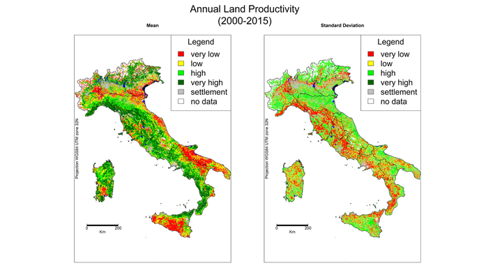 LP average (A) and LP standard deviation (B) for the years 2000–2015.
Abstract
We present a remote sensing-based methodology for the Land Productivity (LP) rapid assessment and monitoring of status and trends at national and sub-national scales. This methodology aims at supporting national and international policies to achieve the Land Degradation Neutrality (LDN) target in the framework of the UN Agenda 2030 and the Sustainable Development Goals (SDG 15.3). The work was performed using the NASA-MODIS Normalized Difference Vegetation Index (NDVI) as proxy indicator of LP status and trends in Italy for 16 years (2000–2015). The assessment of the LP status was based on the pixel mean and standard deviation values of yearly LP values. The LP trends of the yearly time series were computed using Mann-Kendall (MK) and Contextual MK (CMK) tests providing a monitoring indicator for land productivity change. The amount of land with valid increasing and decreasing trends is estimated assuming the 95% significance level of trends in the areas with “good” NDVI pixel reliability. The area of increasing and decreasing LP are estimated for the national territory and for different land covers. The widespread observed increasing LP variations were correlated to the progressive renaturalization of lands subsequent to the decrease of agricultural activities and increasing precipitation trends in the winter season. Decreasing LP affected very limited areas and hot spots were correlated to changes of seasonal precipitation and anthropic activities. The areas and municipalities most affected by LP changes are identified and may support, in the framework of SDG 15.3 and LDN, the identification of policy initiatives.